Drive to Desert View leads to historic tower
DESERT VIEW, Ariz.— Walking through the dark, winding stairs whose walls and ceilings are decorated with beautiful and amazing pictographs will give visitors the impression of walking back in time.
And when reaching the top of the Desert View Watch Tower, the smallest windows reveal some of the most breathtaking views of the Grand Canyon National Park.
The 70-foot-high watchtower is located at the end of the East Rim Drive from the South Rim Village in the Grand Canyon. It is also the first stop in the park for visitors entering from the east from Flagstaff and U.S. Route 89 and State Route 64.
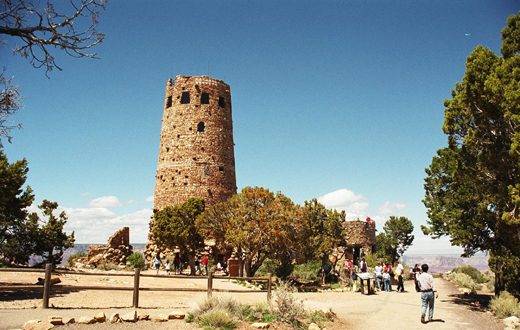 |
| The landmark watch tower at Desert View (Photo by Tiffany Rainey). |
It is the highest point on the South Rim at 7,522 feet above sea level and offers a magnificent view of the northeast end of the canyon.
Looking through one of the small windows of the stone building designed by Mary Jane Colter, to resemble towers found in ancient pueblos like Mesa Verde and Hovenweep, visitors may be shocked by such grandiose beauty.
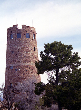 |
Mary Colter’s Desert View Watch Tower rests at the edge of the canyon’s South Rim (Photo by Joyce Oliva). |
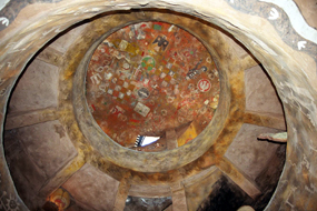
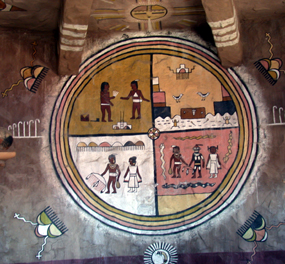
The pictographs and traditional designs covering the walls inside the tower are the work of Hopi artist Fred Kabotie.
One of the depictions is of the Snake Legend, the story of the first person to have floated down the Colorado River. The rest of the pictographs are reproduction of petroglyphs from the Southwest.
“The view is wonderful. It’s a neat place, quiet and secluded,” said Dan Anderson, a frequent visitor to the park.
Every winter and spring, Anderson goes to the canyon in his RV and works at the park.
“And all the views are extraordinary from whatever point you are standing, the view from here is just amazing.”
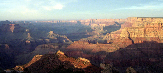
The tower’s observation room or any spot at the lookout point of Desert View offers a view of the cliffs known as the Palisades of the Desert, which are located at the northeast.
|
Looking up to the ceiling (above left) and the wall of the Desert View watch tower (below left), visitors see Hopi art (Photos by Tiffany Rainey and staff). |
Visitors can also see Comanche Point and slightly beyond it is the Little Colorado River, much more visible with binoculars or through coin- operated binoculars which are only twenty-five cents for a couple of minutes.
To the east is the flat top hill called Cedar Mountain, to the northeast tourists can see the endless Painted Desert, and also the Vermillion Cliffs from where they release the California Condors into the wild.
But, to get to this spectacular point, visitors who are entering from the South Entrance Road travel about 25 miles by car or on a tour, since none of the park buses travels all the way to the tower.
|
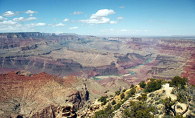
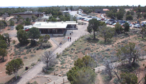
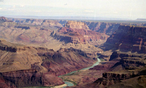
The Grand Canyon and Colorado River at Desert View (top right, photo by Tiffany Rainey). The visitors’ area at Desert View includes a gift shop, a grill, a bookstore, restrooms, and other facilities (Staff photo). |
The park only provides bus transportation to the first three lookout points, which are Yavpai, Mather and Yaki. They are the only ones which are accessible only through the South Entrance Road.
The remaining six-observation points are all accessible through Highway 64, which takes visitors to the East Entrance of the park.
Although Desert View is said to have the best scenery on the East Rim Drive, the rest of the viewpoints are also significant. Each spot has its own enchantment and power to impress visitors.
The fourth stop on the trail, Grandview Point, is one of the highest spots on the South Rim at 7,406 feet and is also one of the busiest, especially at sunset. Most tours that include views of the canyon at sunset drive their customers to this point to enjoy a very peaceful and colorful view.
“The colors are so beautiful. There are no words to describe the feeling you get when you see it first-hand,” said 18-year-old Liliana Perci, who came all the way from Italy to be a front-row spectator of a sunset at the Grand Canyon. “It’s nothing like in the movies; they don’t do it justice, it is so much better.”
 |
| Grandview at sunset (Photo by Joyce Oliva). |
The fifth spot on the trail Moran Point is named after the landscape painter Thomas Moran, who introduced the area to so many through his sketches and oil paintings.
This spot is also the best place to catch a glimpse of the block of rocks known as The Sinking Ship, given because of its similarity to a sinking ship.
The next point is the Tusayan Pueblo, at this location visitors will find the ruins of an ancient pueblo or village by Ancestral Pueblanos. Visitors can walk around and see the stone foundations of two kivas, living areas, and storage rooms.
There also is the Tusayan Museum, which was built in 1932, to celebrate the traditions of the local indigenous people. This very small building displays jewelry, traditional clothing and tools. But, apart from the historic value, the observation point also offers a great view of the San Francisco mountain peaks, which were believed to be the home of a spirit named Kachinas, by the Hopi.
“It’s very interesting. I can’t believe I never stopped here before. It’s my first time at this spot, but my third time at the canyon,” said 34-year-old Henry Marzouca. “It’s interesting. I’ve learned so many things I didn’t know.”
 |
The stop at Lipan Point provides an open view of the Colorado River (Photo by Joyce Oliva). |
Lipan Point, or Lipon depending on who you are asking, definitely gives Desert View a run for its money when it comes to amazing views.
Some spectators have named this the best view by far in the park.
“I like this view much more then Desert View, there are so many layers with different colors and you can see most of the river,” said Vicky Denkus. “This view is spectacular.”
Considered the spot for a colorful sunset and for a great view of the river, visitors can see a glimpse of a couple of the major rapids. They can also begin their hike on Tanners Trail, one of the most difficult trails in the park and one that is recommended for experienced hikers.
The last stop before reaching Desert View is Navajo Point, where visitors are given the gorgeous view of the Grand Canyon Supergroup. The supergroup is several strata of rock tilted at an angle to the other layers of the rock, indicating there was a period of geological mountain building before the layers of sandstone, limestone and shale.
The red, white and black rocks are composed of sedimentary rock and layers of lava.
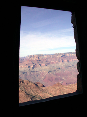 |
A look at the canyon from a window in the Desert View watchtower (Photo by Bruce Garrison). |
“It is a very nice view. You can see this from Lipan Point, except here you can’t see the river. But it’s much more peaceful, not a lot of people at this point,” said Kristina Fuentes who was traveling with her husband and two children.
“It’s still a great view, although not as spectacular as maybe Lipan or Desert View, but it’s still amazing,” she said.
The drive to Desert View can take anywhere from one hour to four hours depending on how many stops are made and how much time is spent at each location. Only one stop has restrooms. They are located at the Tusayan Pueblo.
Gas and food may be purchased at Desert View or at the main South Rim Village and the rest of the stops between the Village and Desert View only offer picnic areas and marvelous scenic views while driving.
 |
A visitor rests to enjoy Yaki Point (Photo by Joyce Oliva). |
The drive offers more variation in color in the canyon and has a better look at the Colorado River and many other breathtaking sights like the Painted Desert or the Cedar Mountain than are found along the West trail to Hermits Rest.
“Wonderful. It’s more then what I expected,” said Geraldine Kingstrom, who was with her husband for the first time at the Grand Canyon.
“I’ve always wanted to come and it’s just what I expected, plus more!”
Comments are Closed