
Biscayne’s historic shipwrecks attract divers
HOMESTEAD, Fla.—Scuba diving is a popular recreational activity in South Florida.
Many divers take to scuba in order to better see, discover and experience the wonderful coral reefs that are in the surrounding waters. But beyond the natural wonders to be found in Biscayne Bay, there lies history on the bay floor.
The Maritime Heritage Trail consists of six recorded and documented shipwrecks off the coast of Miami-Dade County.
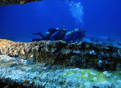 |
Two divers inspect the historic wreck of the Alicia in the waters of Biscayne National Park (Photo courtesy of Biscayne National Park). |
Currently though, only two, the Lugano and the 19th Century wooden sailing ship, are open to the public.
The Biscayne National Park’s resident archeologist and cultural resources manager, Brenda Lanzendorf, and a few volunteers are still mapping the other four.
The shipwrecks that make up the trail were discovered in three ways. First, by local residents who were aware of Biscayne Bay’s environmental characteristics, second by a hydrographic remote sensing survey that identifies what is on the ocean bottom and, lastly, by shifts in the South Florida environment.
“You have a very active environment in South Florida between hurricane, tropical storms and the ocean itself,” Jorge Acevedo, a ranger at the park for eight years, said. “It’s a very dynamic system and sometimes with storms and currents, some of these 200- and 300-year-old vessels could become uncovered from sediments.”
While scuba is the best way to see the shipwrecks, it is not the only way. The Mandalay lies in shallow water perfect for snorkeling.
Free diving is another way to see the ships in deeper water. Park rangers caution individuals to be careful though when venturing into deeper waters, especially if you are not a trained free diver.
The Biscayne National Underwater Park Inc., provides access to the two wrecks available to visitors. Concessions to the other wrecks will also be provided as they become available to the public in early 2007.
| The wreck of the Mandalay rests in the waters of Biscayne National Park (Photo courtesy of Brenda Lanzendorf). | 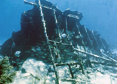 |
The concession is a $62.50 fee, plus tax, for each dive trip, including a fuel service fee and the two tanks needed for each dive trip.
Boat owners who do not wish to use the concession can still gain access to the wrecks by going to the Dante Fascell Visitor Center and get directions to each of the wrecks from the park’s rangers. Underwater site cards are currently being made which will guide divers to each of the six wrecks.
These cards will also contain cautionary notes for divers regarding each of the wrecks. Due to their positions and locations on the bay floor, length of time they have been there and the depth of the water they are in, some of wrecks can pose dangers that divers should be aware of such as fire coral, sharp protruding edges and strong rip currents. The cards will be available as soon all of the wrecks are open to the public.
Lanzendorf recommends divers visit the wrecks during the summer months for best visibility. Clear days and water are harder to predict in winter, so between Memorial and Columbus days is your best bet.
Currently there is no fee charged for accessing the wrecks. However, as more wrecks are opened, a small fee may be implemented in order to aid in the maintenance of the mooring buoys needed for each site. These buoys allow boats to stay near the wreck sites without dropping an anchor that could damage them.
Over the past few years, with funding assistance from the South Florida National Parks Trust, Lanzendorf and volunteers from around the country have map out each of the wrecks and document all of the artifacts that are present at each site.
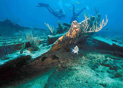 |
The remains of the Arvatoon Apcar in the waters of Biscayne National Park (Photo courtesy of Brenda Lanzendorf). |
“What the park is trying to do is preserve the cultural heritage of the artifacts down there,” Dr. Dan DiResta, coordinator for the Marine Science and Biology Departments at the University of Miami and a frequent scuba diver at Biscayne National Park, said. “They feel it should be available for everyone to see, but there have been artifacts that have been lost by people taking them, so they want to preserve but protect them as well.”
One of the unique aspects of the Maritime Heritage Trail is that not only does it allow visitors a different type of scenery from a conventional dive, but it also illustrates part of South Florida’s history.
“It gives you a great idea of what the Florida Keys and Biscayne National Park used to be like,” DiResta said.
Lanzendorf further explained:
“The driving catalyst is to provide an educational experience to teach people that the wrecks are not just recreational destinations. They are archeological deposits that tell us about past behavior. Archeologists study them as ways to get at past human behavior that isn’t necessarily found in historical documents.”
Officials at Biscayne National Park stress the importance of respecting each of the shipwrecks in the bay by not touching or taking items from the remains. Divers are free to take pictures but asked not to disturb the artifacts.
“Just observe, enjoy and experience,” Acevedo said.
As a unique part of south Florida history, park officials strive to ensure that the shipwrecks are kept in tact and preserved to the best of their ability.
“The most important things we do is protect the resource for present and future generations and if we don’t protect it, we are actually failing to do our obligation,” Acevedo stated.
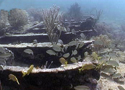 |
The Lugano waits for divers in the waters of Biscayne National Park (Photo courtesy of Biscayne National Park). |
If You Go
Directions to Biscayne National Park:
- From the North: The park entrance at Convoy Point can be reached from either the Florida Turnpike or U.S. 1.
- From the Florida Turnpike: Take the Florida Turnpike South, to Exit 6 (Speedway Blvd.). Turn left from the exit ramp and continue south to SW 328th Street (North Canal Drive). Note: There will be a small brown sign on the right-hand side of the road pointing to SW 328th Street. Turn left and continue until the end of the road. It is approximately nine miles and the entrance to the park is on the left.
- From U.S. 1: Drive south to Homestead. Turn left on SW 328th (North Canal Drive) and continue until the end of the road.
- From the South: Traveling on U.S. 1 (Overseas Highway), drive north to Homestead. Turn right on SW 328th Street (North Canal Drive) and continue to the end of the road. The entrance is approximately nine miles on the left.
For more information:
- Biscayne National Underwater Park, Inc. (park concessions operators) 305-230-1100.
- More information on each of the shipwrecks can be gained by visiting the park’s Web site at http://www.nps.gov/bisc/historyculture/maritime-heritage-trail.htm.
| Marine archaeologist David Choat maps the wreck of the Earl King (Photo courtesy of CMAR). | 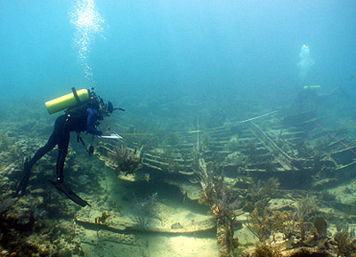 |
Comments are Closed