
Point Bonita offers top bridge, bay views
SAN FRANCISCO — When I asked Liz Lewis, 29, a resident of Sacramento, and John Roberts, 56, who is from San Francisco, what brought them to Point Bonita lighthouse, they simultaneously gazed into each other’s eyes, looked at me, smiled, and said, “romance.”
“The lighthouse is a place that makes nature resonate within you and makes your body feel good,” Lewis said. “But being here with [John] is what makes it number one.”
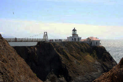 |
The Point Bonita Lighthouse rests on a rocky piece of the shoreline at the entrance of San Francisco Bay (Photo by Anthony Minerva). |
Point Bonita is located in the Golden Gate National Recreation Area, at the southwest tip of the Marin Headlands. Its lighthouse still functions today as guide for ships entering the San Francisco Bay.
The lighthouse was built in 1855 in an area a little higher into the Headlands, but was moved to its current location in 1877 when ship captains complained that the fog made the light almost invisible.
The lighthouse uses both visual and acoustic aids to help to navigate the ships entering the area. A total of 150 glass prisms are used to strengthen the beams that the lighthouse emits. The prisms that surround the 1,800-watt Halogen bulb are used to “reflect the light, refract the light, and magnify the light so that it is able to reach 18 miles into the sea,” Tom Delebo, Point Bonita Lighthouse docent, said.
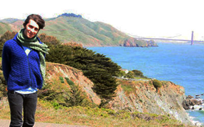 |
The author poses at Point Bonita with the world-famous Golden Gate Bridge in the background (Photo by Nicole Alibayof). |
On days where the fog is too thick for the light to penetrate, it is detected by a fog sensor. The result is the sounding of an electric fog horn which is sounded twice every 30 seconds, which is meant to continue to guide the ships that pass through. Luckily, on the day I went, there was not a bit of fog in sight. The views of the bay were crisp and absolutely breathtaking.
The trail to Point Bonita lighthouse begins at the parking lot, but if there are no spots, parking along the road is fine. Though the trail may only be a half-mile long, it is hilly and steep at points. It is graced with countless scenic vistas of the Golden Gate and the bay on both sides of it.
The trail is located at the edge of a cliff, with the waves of the bay breaking on the rocks about 150 feet below you on your left. If it is a windy day, you may be able to catch the faint smell of the sea water that is carried from down below.
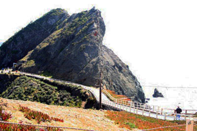
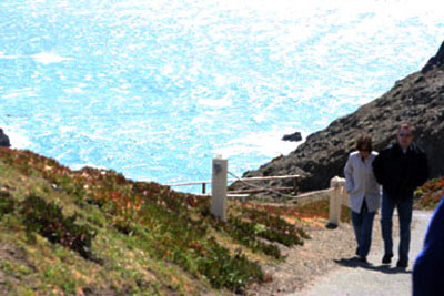
| A visitor walks toward the Point Bonita Lighthouse at Golden Gate National Recreation Area (Photo by Anthony Minerva). |
 |
Cabbage plants from previous lighthouse keepers still spring up annually, John Martin, an intern for the National Park Service, said.
It’s fairly common for newlyweds to come to this part of the Marin Headlands to take pictures in their wedding clothes or families to come and take their family pictures.
About halfway through your walk you’ll walk through the first of two bridges that you need to cross in order to get to stand inside the lighthouse. Standing on the steep bridge, you’ll see the city to your left, and the open horizon on your right. Continue walking and you’ll pass some guardrails on your left and a beach down below.
“Back in the 1980s, before there were guardrails, we would sneak down to the beach,” local resident Roberts said.
After passing the beach, the winding road will take you through a dark, moist tunnel, which may be a perfect place to sneak a kiss with your significant other, as a couple who was when I was did.
If the strong winds haven’t blown you off course, you’ll walk a little more through the winding path and see the lighthouse in the distance, with a usual line waiting to get across the bridge, which only can hold two people at a time, due to the fact that it is held up by cable suspensions.
| Point Bonita Lighthouse Docent Tom Delebo super- vises footbridge traffic. (Photo by Anthony Minerva). |
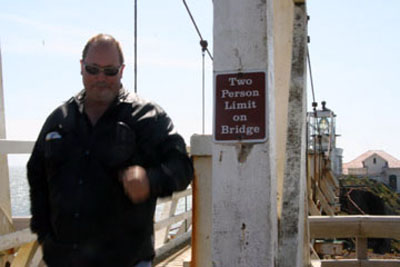 |
“When the winds are more than 35 miles per hour, we close the bridge and wait for them to slow down,” Solange Russek, a park guide for the National Park Service, said.
Once inside the lighthouse, you’ll find information about different marine related things, such as area maps and how to tie bowline, square, and sheet bend knots. Upon exiting the lighthouse make sure to stand at the very tip to be at the furthest point of the Marin Headlands. On a clear day, you’ll see the whole city and the beginnings of the Pacific Ocean.
 “Being at the lighthouse makes us see why the bridge is called the ‘Golden Gate.’,” Martin said.
“It’s the only place in San Francisco where you can see the history of it and experience the natural resources.”
“Sunlight does something different to the body at the lighthouse,” Roberts said. “It invigorates and refreshes your body and soul.”
The lighthouse attracts about 300 visitors per weekend consistently throughout the year, Russek said.
If You Go
- The only time visiting the lighthouse is open to the public is Saturdays through Mondays from 12:30 to 3:30 p.m.
- Group tours may be arranged at other times by calling and making reservations to see if a docent is available.
- Wear walking shoes as the trail is steep.
- Portable restrooms are available at the beginning of the trail.
- Snacks and refreshments are located in the Marin Headlands bookstore, one mile away from Point Bonita on the way there from the entrance of the headlands.
- Bring a camera!Directions
From the North
– Take Hwy 101 southbound.
– Exit at second Sausalito exit, just before the Golden Gate Bridge.
– Bear right onto Alexander Avenue; proceed back under the freeway.
– Follow Alexander Avenue 0.2-miles; turn left onto Bunker Road.From the South
– Take Hwy 101 northbound across the Golden Gate Bridge.
– Exit Alexander Avenue; bear right.
– Follow Alexander Avenue 0.2-miles; turn left onto Bunker Road.Directions to Point Bonita Lighthouse
– On Bunker Road, pass through one way Baker-Barry Tunnel.
– Follow Bunker Road three miles; turn left on Field Road.
– Follow Field Road 0.8 miles to Point Bonita parking lot and trailhead.
– Walk the half-mile trail to the lighthouse.
Comments are Closed