Tram offers easy way to tour Shark Valley
HOMESTEAD, Fla.— Many South Floridians grow up without ever visiting Everglades National Park, only an hour or so drive from the metropolitan Miami area.
Driving to Everglades National Park takes you through a variety of landscapes. You start at the concrete jungle of downtown Miami.
The route down U.S. 1 continues through suburban areas and the dense forest of concentrated populations, houses and stores. Traffic becomes less congested as you continue south. Chain department stores and mini-malls soon yield to smaller shops and open space.
It is a sight that many Miami residents don’t take advantage of often enough.
But bold Miamians should venture a little past the boundaries of the metropolis to join one million visitors from all over the country and the world who come to the Everglades each year. You will enjoy the unique environment and the change from a bustling city.
 |
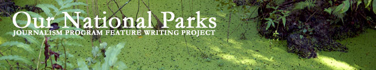
A park ranger provides an interpretive tour for visitors at Royal Palm in Everglades National Park (Staff photos). |
Standing at the edge of the Everglades, it doesn’t look like much. There are small ponds surrounded by vegetation, seemingly unending fields of overgrown sawgrass and towering trees in the distance.
Even those who take the 38-mile drive from the Coe Visitor Center to the Flamingo Visitor Center are missing out on the Everglades experience. You must get out of your car, give your shoes a little exercise, and enter into the park to see what make the Everglades special.
“There are no other Everglades in the world,” boast signs at the Coe Visitor Center. Stop there, at the east entrance of Everglades National Park, for an introduction to the park’s history, present and future.
For example, you will learn that Ernest F. Coe, for whom the visitor center is named is considered the father of the Everglades. In 1928, Coe first proposed a national park to be delineated within the lower everglades of South Florida.
At the visitor center you can ask any questions you may have.
 |
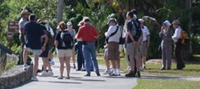
The Coe Visitor Center at the park’s Florida City entrance. |
A park ranger, like Bob Merkel, will be available to answer your questions before you enter the park.
A man from Holland asks, “How long is it going to take to get through the park?” Merkel asks back, “How long do you have? What do you want to see?”
Then he gives him a map and park information in Dutch.
Merkel can give you advice on where to see the best wildlife and representative Everglades land.
If the rangers don’t fulfill your thirst for information (but believe that they are very knowledgeable about Everglades National Park), a 15-minute video about “Pa-Hay-Okee,” what the native Indian population calls the Everglades, helps explain the tropic / temperate environment and annual cycles of wet and dry periods that shape the ecosystem, yielding the unusual plants, animals, and habitats.
 |
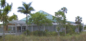
| A panther crossing sign. |
There are six distinct habitats in the Everglades: the freshwater slough, hardwood hammocks, pinelands, cypress swamps, sawgrass prairies and mangrove estuaries.
The freshwater slough is coined the “river of grass” from Everglades: A River of Grass by Marjory Stoneman Douglas, an Everglades preservation activist.
Lake Okeechobee, near West Palm Beach, feeds the marsh and it transports water to the rest of the Everglades. The flooded prairies are the predominant habitat of the Everglades.
For the best view of the freshwater slough, enter the park at the Shark Valley northern entrance off of U.S. 41. Take any of the trails at Shark Valley to get a glimpse of the slow moving sawgrass swamp.
Higher elevations of land in this area have become pear-shaped, tree-dotted islands called the hardwood hammocks. Tropical species of mahogany, gumbo limbo and cocoplum trees grow alongside live oaks, maples and hackberry.
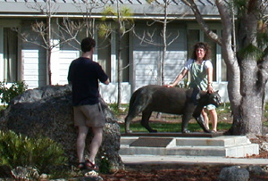 |
The Florida Panther statue at the entrance of the Coe Visitors Center at Florida City is a popular location for visiting photographers. |
These trees wouldn’t survive the often flooded Everglades, but the respites of higher elevation, where surrounding limestone has been eaten away by decaying plants, protects them from high waters.
A sub-habitat of the hammocks, called a bayhead, lies on a lower elevation and houses trees that can tolerate wetter environments.
A little further into the park from the Royal Palm Visitor Center is the Long Pine Key Trail. It will take you through pinelands, prairie and cypress swamps.
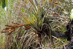 |
An airplant grows — on moisture in the air, rainfall, and any nutrients that may fall onto it — on a tree along Anhinga Trail at Royal Palm, but the airplant does not harm its host. |
The slash pine is the dominant plant that lives on higher limestone ridges in the park. These areas are called the pinelands.
The cypress swamps are found in areas where the land is low and water collects. Cypress trees are well adapted to live in deeper standing water.
Sawgrass prairies are expansive field of vegetation, drier than the Freshwater Slough.
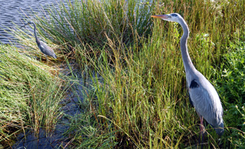 |
| Wild birds at Royal Palm. |
Mangrove estuaries occur where freshwater and saltwater meet.
Mangrove trees have specially adapted roots and leaves that enable them to occupy the salt wetlands where other plant life cannot survive.
These estuaries are home to shrimp, fish and numerous birds that enjoy wading. The most recognized area of mangrove estuaries is the 10,000 islands.
“You can’t see any of these things, all in one place, anywhere else in the world,” said Zoe Makris, a park visitor from Greece.
Comments are Closed