
Shenandoah Park trails offer views
Note: Mile markers (MM) are located along the Skyland Drive, beginning at the north entrance of the park near Front Royal, Va., at MM 0. Distance time is based on round trip.
Before you set out on a hike, remember to stop at a visitor information center for trail maps, current trail conditions and other information.
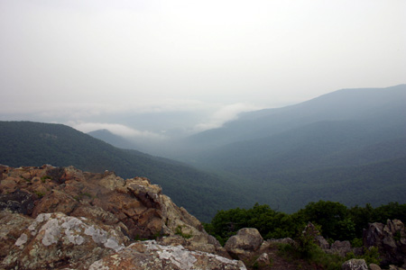 |
Views of the Shenandoah Valley from trails are breathtaking (Photo by Tenille Lively). |
Fox Hollow Trail (MM 4.6)
Click on this link for a complete look at the history behind the popular Fox Hollow Trail, located at the Visitor Center at MM 4 on Skyline Drive.
Distance: 1.2 miles, 1.0 hour
Elevation Gain / Difficulty: 310 feet / Easy
Hickerson Hollow (MM 9.2)
This horse trail descends through Hickerson Hollow. Several mountaineer homes once existed along this trail
Distance: 2.2 miles, 2.5 hours
Elevation Gain / Difficulty: 940 feet / Fairly Easy
Compton Peak (MM 10.4)
Somewhat rocky, occasionally steep trail with exceptional scenic views. Outstanding examples of columnar jointing.
Distance: 2.2 miles, 2.5 hours
Elevation Gain / Difficulty: 940 feet / Fairly Easy
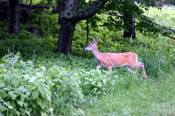 |
A deer scampers near a trail at Skyland in Shenandoah National Park (Photo by Tenille Lively). |
Overall Run (MM 22.1)
Occasionally steep hike that leads to the park’s highest waterfall.
Distance: 6.0 miles, 5.5 hours
Elevation Gain / Difficulty: 1,200 feet / Moderate
Little Stony Man Cliffs (MM 39.1)
An easy hike that rewards the hiker with excellent views.
Distance: 0.9 mile, 1.0 hour
Elevation Gain / Difficulty: 300 feet / Easy
Stony Man Trail (MM 41.7)
Gradual climb to second-highest peak which follows a portion of the Appalachian Trail.
Distance: 1.6 miles, 1.5 hours
Elevation Gain / Difficulty: 340 feet / Fairly Easy
Whiteoak Canyon (MM 42.6)
Strenuous hike to the first of six falls with views of the ancient Limberlost hemlocks.
Distance: 4.6 miles, 4.25 hours
Elevation Gain / Difficulty: 1,040 feet / Strenuous
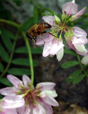 |
Wildlife in all shapes and sizes can be seen along the trails of the Shenandoah National Park (Photo by Tenille Lively). |
Limberlost Area from Crescent Rock Trail (MM 45.6)
Begins across drive from Crescent Rock Overlook at a market. Leads to grove of Limberlost hemlocks where Indian pipes and other shade-loving plants grow.
Distance: 3.3 miles, 2.25 hours
Elevation Gain / Difficulty: 500 feet / Fairly Easy
Hawksbill Mountain Summit (MM 46.7)
Rocky trail to summit of park’s highest peak at 4,049 feet, where balsam fir and rare red spruce can be seen.
Distance: 2.1 miles, 2.0 hours
Elevation Gain / Difficulty: 520 feet / Moderate
Dark Hollow Falls (MM 50.7)
Excellent view of Dark Hollow Falls.
Distance: 1.5 miles, 1.5 hours
Elevation Gain / Difficulty: 440 feet / Moderate
South River Falls (MM 62.8)
Fairly steep trail through lush woods with view of the falls.
Distance: 2.6 miles, 2.25 hours
Elevation Gain / Difficulty: 850 feet / Moderate
Frazier Discovery Trail (MM 79.5)
Discover trees, ferns, wildflowers and birds along this short loop. The hike’s midpoint, at the top of Loft Mountain, offers a stunning vista. Named for a family that lived nearby in pre-park days, this trail is for all ages.
Distance: 1.3 miles, 1.5 hours
Elevation Gain / Difficulty: 455 feet / Moderately Easy
Blackrock Summit (MM 84.8)
Outstanding views and rock outcroppings.
Distance: 1.0 mile, 1.25 hours
Elevation Gain / Difficulty: 175 feet / Easy
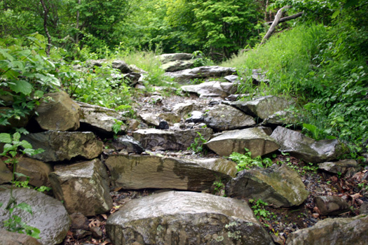 |
| The landscape of Shenandoah National Park along one of the trails (Photo by Tenille Lively). |
Comments are Closed